I have been looking at your points and I would say the error of your measured points is too large for what you are trying to do, I guess you already knew since you said:
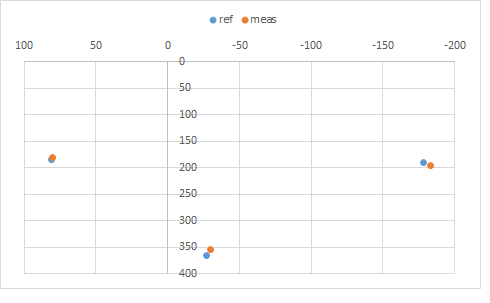
I have plotted the two sets of ABC points and I see the distance between the measured A and B varies noticeably with respect to the distance between the reference A and B:
Moreover, the measured points are not just rotated and transated with respect to reference points, there is a small distortion of their relative position. Thus, we can’t rely on the relative position of the measured points to define their coordinate system as we have done above.
Can you define de reference points? The effect of the errors of the measurements would be smaller if the references can be placed as far apart from each other as possible (on the corners). Other than that…
What is the precision you need for your measurements?
Thanks a huge load again, Julen!
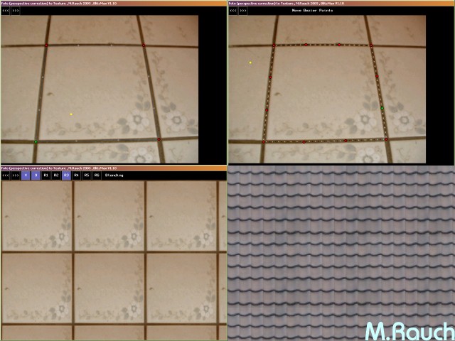
Sadly, I can neither determine the color patch size nor the tolerance. They are user-definable. Of course they should be of considerable size to allow human and mechanical tolerances, but I have no influence on anything more than user ratio. Ideally the reference points should form an enclosing right-angled triangle, but as you see from this real-world example they can be anywhere else.
Seeing the mathematical issues, I am considering a brute force approach rather: Determining the distance of each patch to the three reference points and adding a measured point deviation based on the inversion of their distance to each point. That could work out good enough. I guess much like @MarkusR mentioned. And I do not want to overuse your time and kind assistance that much.
what i have done in past was this based on some points to create a game texture.
it remove the lense bending. it used a interpolation for both x,y axis.
mensuration 4 points = 4 lines and each line was 4 point Bézier curve with 2 helper points.
maybe u can use this idea somehow.
I don’t get what you are proposing here. If it is measuring the distance from each color patch to the measured A, B and C points and using those three distances to define the point that is at those same distances from the three reference points, it will work, mathematically. But I believe the measurement errors will prevent you from getting a result, at least if you are planning to do it as I think it can be done.
If what you meant was you are going to calculate an average offset using the measured positions of the reference points that you will then correct for all measurements, this approach will ignore rotation but at least you will get a result. Depending on the precision you need, it may be enough, I have to admit I don’t know what all this is for so I can’t assess that.